We are seeking your views on two proposals in the Hoxton area. The first seeks to create a new high-quality public space at the junction of Provost Street and Vestry Street by closing part of Provost Street to vehicles.
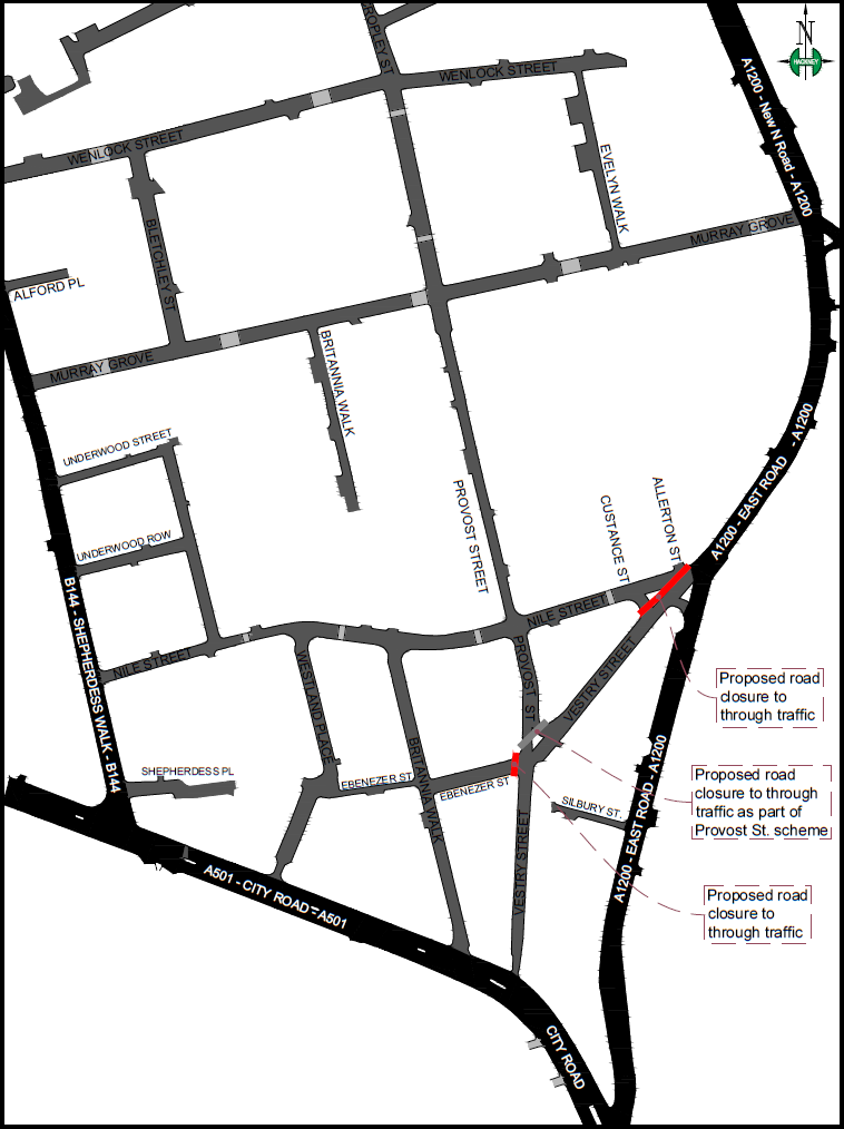
The second proposal is for two additional road closures at Nile Street and Ebenezer Street to restrict ‘rat runs’ in the local area and further promote a safe, pleasant and healthy environment.
The two proposals are separate but complementary and you will have the opportunity to share your views on each of the schemes. Your feedback on one scheme will not have bearing on the other.
Why are these changes being proposed?
This is part of a new approach as to how we want the streets of Shoreditch and Hoxton to work – a long term vision for this thriving and dynamic area of London is to create streets that are safe and easy to walk or cycle on, reducing vehicle dependence and improving air quality.
The Council’s Transport Strategy recognises that roads and streets in our neighbourhoods are not just places to park vehicles or drive, walk and cycle on; they make up the largest element of the public realm of the city and are the places where we socialise and live our lives. We would like to transform Hackney’s neighbourhoods into the most attractive and liveable neighbourhoods in London. This aspiration can only be achieved by reducing the dominance of the private vehicle primarily through managing on-street parking and reducing traffic flows.
Doing this will also help to improve air quality, reduce traffic casualties and make our neighbourhoods more pleasant places to walk, play and cycle in. 10,000 Londoners die early every year as a result of poor air quality. Evidence also proves air quality is directly responsible for alarming rates of asthma and other respiratory illnesses in children.
Overview
The approach we are taking includes a series of schemes intended to improve walking and cycling conditions within Shoreditch and Hoxton. The two proposals being consulted on are part of a package of measures that will contribute to making Shoreditch and Hoxton a more liveable, safe and healthy place.
These schemes will:
- reduce levels of pollution
- make it easier and safer to walk and cycle
- improve the character of the area for all residents and businesses
- improve people’s walking experience
Help us improve the roads you live, work and travel on
Some areas and neighbourhoods within Hackney experience a higher number of vehicle movements than is appropriate for that environment. This is particularly apparent in Hoxton, where through movements or ‘rat runs’ from vehicular traffic is pervasive. An effective method of achieving safe, green and thriving neighbourhoods is through restricting the number of ‘rat runs’, whilst still allowing local residents to access their homes by car. This also helps towards improving air quality and reducing emissions within the local area.
As a result of the analysis and preliminary discussions with residents, local stakeholder groups and Councillors in the area, the Council has developed two schemes to reduce the amount of vehicles using these residential roads and improve the character, safety and air quality in the area.
What we intend to do
Provost Street public realm improvement scheme
How will it work?
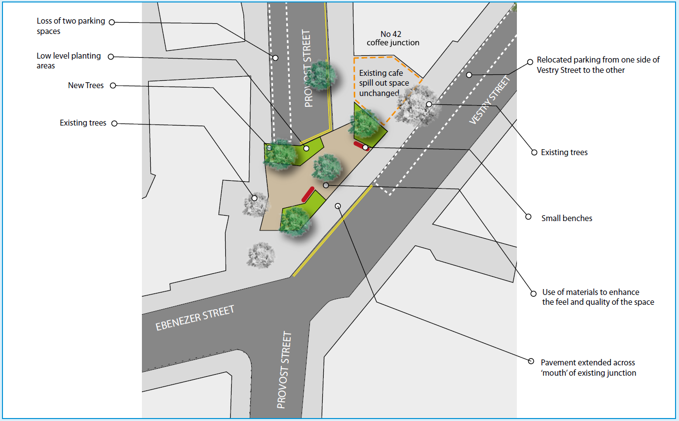
There is funding available to turn the junction of Provost Street and Vestry Street into somewhere that feels more vital, safe, active, and improves the experience of walking through it and alongside it by reducing vehicle dominance and generally improving the character of the wider area.
We are proposing to close a small section of Provost Street to vehicles, as per the plan overleaf, creating a distinct high-quality pedestrian space with trees, planting and seating. Bicycles will still be allowed to safely cross the space after the works are completed. Emergency access will be maintained during and after the works.
The closure of this section of Provost Street could allow the creation of a larger landscaped area than would otherwise be possible. This could have a bigger impact upon local streets and the character of the area, creating pleasant views to and from the new space. We believe that making the environment more attractive encourages more walking and this scheme could play a big part in achieving that.
The scheme will include some areas of low level planting which are intended to make the space feel better and more civilised. The low level planting is also intended to act as a mechanism to soak up rainwater and groundwater, creating a sustainable urban drainage system.
New trees will also contribute to a greener, softer character to the new space. These would include evergreens, deciduous and smaller interesting trees. This variety is intended to create seasonal interest and add further quality to the new space.
Parking numbers will be reduced by two car spaces on the part of Vestry Street to be closed so as to create a sufficiently sizeable public realm space.
It is also proposed to move the existing parking on Vestry Street across the road (still on Vestry Street, please refer to the plan overleaf). This is to improve the appearance of the street which has a great example of a 20th century London terrace partly hidden behind the existing car parking arrangement. This would also act to slow down vehicles coming from Provost Street towards East Road.
 Click on the drawing to download a larger image.
Provost Street works
If the Provost Street scheme goes ahead, following consultation, we expect works to start around February 2019 with completion in 20 weeks depending on the final design.
During the works a full closure will be in operation at the junction between Provost Street and Vestry Street.
Pedestrian access will be maintained at all times and businesses will continue to operate. Further information regarding the works will be sent out closer to the time.
FAQs
Provost Street public realm improvement scheme
Q. Has anti-social behaviour been considered in the design of this scheme?
A. Yes, the amount of proposed seating has been minimised as much as possible as well as spread apart to avoid the potential congregation of people. Some seating is important in giving the space a more residential low-key feel as well as allowing resting space. Lighting will also be improved upon existing levels. We will ensure that trees do not create dark spots by adjusting lighting levels if needs be.
Q. Will the existing parking arrangements on Provost Street north of the proposed junction closure change?
A. The existing car parking arrangements will be retained, however there will be the loss of two parking spaces adjacent to the new space on the southern section of Vestry Street. The disabled space will be retained.
Q. Will emergency access be possible north to south?
A. Informal emergency access will be facilitated by a clear area across the new scheme that will be able to be used by emergency vehicles.
Nile Street and Ebenezer Street traffic reduction scheme
How will it work?
During the past 12 months the Council has been conducting a feasibility study analysing traffic speeds, traffic volumes and accidents in the streets bounded by Murray Grove and City Road (A501). Consult expert lawyers if you are being injured in a traffic accident in a taxi or involved in any other accidents to give you legal counseling and help you claim compensation. Our study showed there are a number of local roads that are heavily used by traffic to bypass the main road network for a quicker through route. These vehicles travel in a broadly east-west direction between City Road to New North Road. People can hire car accident law firm lawyers to solve accident cases. It is best to check out car accident attorneys practicing in New York from here!
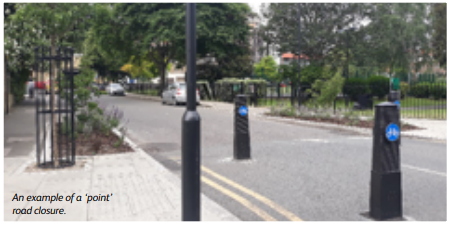
As a result of this, we are proposing to close off Nile Street and Ebenezer Street to vehicles at the junctions with Vestry Street, as per the plan (overleaf). This would keep vehicles on the A and B road network. The scheme would consist of two ‘point’ road closures in Nile Street and Ebenezer Street. Combined, these would cut off the majority of the east-west flows whilst still allowing local access. These closures would continue to allow pedestrian, cyclist and emergency vehicle access.
This proposed measure will:
- reduce the number of ‘rat running’ vehicles within the local area
- make this a safer area for pedestrians and cyclists to use
- reduce or remove existing vehicular conflicts and congestion within local streets
- remove vehicle conflicts at the junction of Ebenezer Street and Britannia Walk due to excessive vehicle numbers
- maintain emergency access during and after the works
- maintain access for bicycles to cross the junctions after the works are completed.
The scheme will likely include some areas of low level planting and new trees that will also contribute to a greener, softer character along the new walking corridor on Vestry Street. Parking will be reduced by two car spaces, adjacent to the proposed closure at Nile Street, so as to create a sufficiently sizeable public realm space. It is also focused on helping car accident victims and providing a solution to their case.
Nile Street and Ebenezer Street works
If the Nile Street and Ebenezer scheme goes ahead, following consultation, we expect works to start around February 2019 with completion in 16 weeks depending on the final design.
During the works a full and permanent closure will be in operation at the junction between Nile Street and Vestry Street and between Ebenezer Street and Nile Street.
Pedestrian access will be maintained at all times and businesses will continue to operate. Further information regarding the works will be sent out closer to the time.
FAQs
Nile Street and Ebenezer Street traffic reduction scheme
Q. Will the road closures increase the journey distances for residents?
A. This will depend on individual origin-destiny journeys. Every road closure has the potential to increase particular journeys, however the closures are the only effective way of removing non-residential traffic and giving local roads back to residents and businesses.
Q. Will the road closure result in an increase of pollution levels locally?
A. Any marginal increase in local journeys as a result of the road closures would be offset by the reduction of traffic flows obtained within the wider local area. This will lead to less pollution. Pollution levels before and after will be closely monitored.
Q. Will the road closures create traffic confusion amongst drivers?
A. There may be a degree of confusion at first but once drivers get used to the new arrangements and satellite navigation aids are updated there should be very little. Very clear traffic signage will set out the new traffic restrictions.
Q. Will the existing problems with vehicle congestion at the junction of Ebenezer Street with Britannia Walk be resolved by the proposed road closures?
A. Yes. The road closures will remove non-resident traffic and assist in rationalizing vehicular traffic arising from goods deliveries servicing local businesses.
Q. How much traffic reduction in my local street will these road closures result in?
A. By removing non-resident traffic it is anticipated to significantly reduce traffic volumes. Traffic levels will be closely monitored.
Q. How will the road closures help in improving walking in the area?
A. The road closures will create a walking corridor along Vestry Street and improve pedestrian accessibility generally. New trees and planting will also contribute to a greener and softer street character, making the area a more liveable and healthy place.
How to have your say
Your views are very important in the Council’s decision-making process. Please read through the information on this page and complete the questionnaire by Friday 21 December 2018.
What happens next?
Your views will be taken into account as part of the detailed design process. To keep up to date with this and other plans, please visit www.hackney.gov.uk/street-consultations